
How much do you know about typhoons?
Many netizens are paying attention to the news of super typhoon "Du Surui". According to the forecast of meteorological experts, Du Surui may become one of the most serious typhoons in the 21st century, and may also be the strongest typhoon registered in southern Fujian since 2017 and the strongest typhoon affecting eastern Guangdong in recent 10 years.

Source: Central Meteorological Observatory
So, how does a powerful typhoon form?
The essence of a typhoon is a vortex formed by a large number of cumulonimbus clouds gathering together. The surface water temperature of the low latitude ocean near the equator is relatively high, and the collision between wind and wind easily forms ascending airflow, which leads to the continuous development of cumulonimbus clouds. Cumulonimbus clouds like this, which form in tropical oceans, are the seeds of typhoons.
Water vapor carried aloft by ascending air currents condenses into water droplets (cloud droplets), releasing heat to the surroundings (condensation heat). That is, cumulonimbus clouds that form in tropical oceans release a lot of heat. As growing cumulonimbus clouds gather into clusters, the heat released by the cumulonimbus clusters causes the pressure near the sea surface to decrease. Eventually, cumulonimbus clusters will transform into "tropical cyclones."
Winds blowing toward the center of a tropical cyclone, especially from the ocean surface where the temperature exceeds 27 ° C, carry large amounts of water vapor, which allows tropical cyclones to flourish, with lower pressure and stronger wind speeds. When the maximum wind speed near the center exceeds 17 meters per second (i.e., reaches Category 8 winds), it is called a typhoon.
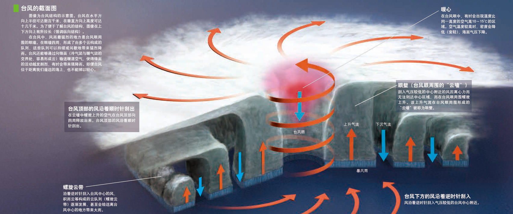
Strictly speaking, in meteorology, only when the wind speed reaches 33 meters per second, that is, when the wind is 12, it can be called typhoon, while when the wind speed is 17~33 meters per second, it is called tropical storm and severe tropical storm. However, since tropical cyclones reaching tropical storm status are numbered and named, they are customarily called typhoons.
Typhoon level can be used "typhoon""strong typhoon""super typhoon" and so on. A typhoon in a narrow sense means that the maximum average wind speed near the bottom center is 33~41 meters per second (wind force 12~13), a strong typhoon means that the wind speed is 41~51 meters per second (wind force 14~15), and a super typhoon means that the wind speed exceeds 51 meters per second (wind force 16 or above). The lower winds are called severe tropical storms, tropical storms and tropical depressions. Because typhoons develop and decline continuously in their life history, they will experience different intensities, and the highest intensity they reach is called extreme intensity. About 16.5 tropical cyclones, 10.5 strong typhoons and 5.8 super typhoons form in typhoon season every year. Secondly, the scale of typhoon is often measured by the radius of the area reaching a certain wind speed, such as the radius of the 10-level wind circle and the radius of the 7-level wind circle.
The following chart shows the track forecast of a typhoon. The map shows the typhoon's current location, the "storm zone"(an area with average winds of more than 25 meters per second) around the typhoon, the strong wind zone, and the typhoon's path before it.
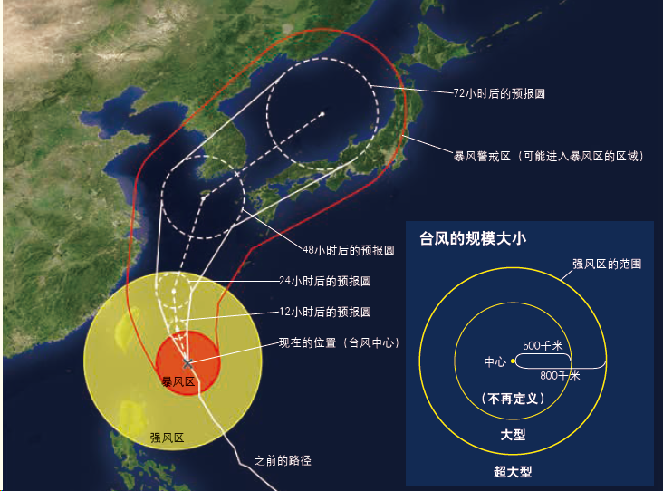
In addition, there is a "forecast circle" showing the future path of the typhoon. The forecast circle indicates the range where the probability of arrival of the typhoon center is higher in the future. The probability of typhoon center entering the forecast circle is about 70%.
It is often mistaken that typhoons pass through the center of the forecast circle, but this is not the case. A "storm warning zone" is an area with a high probability of entering a storm zone that extends beyond the forecast circle, so be cautious.
When heavy rain or storm may bring disaster, meteorological department will issue meteorological disaster warning corresponding to the phenomenon. According to the degree of harm, emergency and development trend that disasters may cause, they are divided into four levels: IV (general), III (severe), II (severe), I (especially serious), which are indicated in blue, yellow, orange and red. The government and relevant departments will make corresponding emergency preparations according to different levels, and inform the public through various means such as radio, television and the Internet. When receiving a disaster warning, be sure to carefully plan the next action to prevent being affected by the disaster, and be fully prepared for those that cannot be avoided. For extremely serious disasters, we should pay attention to evacuation information and immediately carry out self-protection.
Now you can know a typhoon is coming days in advance, but you'll suddenly be hit by lightning and torrential rain. To protect ourselves better, can we know in advance when and where it will thunder and rain?
The weather service's nowcasts provide just that information. The weather department will issue a precipitation forecast for the next two hours and a lightning forecast. Rainfall forecasts give precise information about a location on a map: "light rain in 15 minutes, moderate rain in 70 minutes"; lightning forecasts give information about the intensity and frequency of lightning.
Weather forecast is to forecast weather conditions in the next two hours by using information obtained from radars, rain gauges, lightning locators and satellite lightning positioning systems installed in various places in the past few hours. If abnormal conditions such as sudden darkening of the sky or temperature drop are found, you can use smart phones to inquire about the risk of rainstorm and lightning in your location (precipitation forecast can be inquired in various weather application software, and lightning forecast needs to be inquired by "China Lightning" application software launched by Public Meteorological Service Center of China Meteorological Administration).
Weather knowledge and information can save our lives!
Every year, various meteorological disasters are formed, resulting in a large number of deaths or disappearances. Please pay close attention to the early warning and other information issued by various departments, and do not underestimate the danger without authorization, so as to better protect your own life and property safety.
This article is excerpted from Science World, Issue 10,2019, Science of Weather Forecast